Bending Reality: Where arc and science meet
Nature is curved. From tangled branches to meandering rivers and irregular coastlines, there is barely a straight line to be seen. In centuries past, information designers have sought to emulate this, with tree-like diagrams and twisting connections, but others have objected to the inefficiency of curves. Straight lines are direct, simple and easy to follow, so why take pointless diversions?
Straight lines can play a part in simplifying the world, highlighting routes and connections, but they can only go so far, and sometimes curves may be better suited. Whether these are free-form Béziers or regular geometric patterns, in some circumstances they can be more effective or more aesthetic, and the task of the information designer is to take a flexible approach, identifying the best tools and techniques for the particular task to hand.
This exhibition presents information from a variety of contexts, the linking theme is that the designers have investigated the use of curves in order to show routes, structures, movement, time and connections.
Organized by
Maxwell J. Roberts, University of Essex, UK
Stephen Kobourov, University of Arizona, USA
Martin Nöllenburg, Karlsruhe Institute of Technology, Germany
in association with Dagstuhl Seminar 13151.
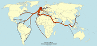
Curved annotations of the world
The world is a sphere, but even when it is shown as a flat projection, curves are often used, especially to show movement.
show Gallery (4 Pictures)
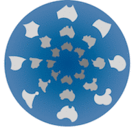
Curving the world
Curves in the world are rarely simple, whether twisted gnarled branches or a fractal coastline. Even man-made structures such as railway lines can have complex, uncertain trajectories. These can be smoothed and simplified, but sometimes there is a temptation to go further, turning the world into alien geometric shapes.
show Gallery (4 Pictures)
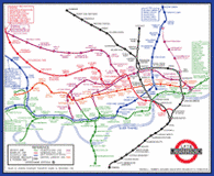
Early metro maps
The most widely used examples of the curves of reality being converted into straight lines are metro maps worldwide. This information design technique is relatively recent, first used in Berlin (1931) and London (1933). Before this, curves on maps generally were used in an attempt to represent reality. However, there are also examples of attempts to simplify, even going as far as using a regular circle.
show Gallery (6 Pictures)
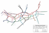
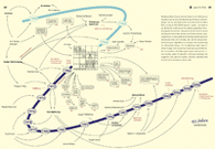
Metro maps using freeform Béziers
Sometimes, straight lines fail to simplify reality. In the case of a complex highly interconnected network, gentle curves smooth away harsh zigzags, potentially revealing the underlying structure of the networks.
show Gallery (6 Pictures)
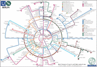
Metro maps using concentric circles
Highly abstract and stylised, this new way of showing networks does not necessarily offer simplified line trajectories, but nonetheless presents a highly organised view of the network, which many people find striking.
show Gallery (5 Pictures)
Curved relationships
In theory, the display of abstract concepts such as time and relatedness need not be constrained by preconceptions derived from our experience of nature. In practice, use of curves can add an aesthetic dimension, or even assist in the presentation of information.
show Gallery (5 Pictures)
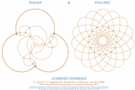
Mathematical abstractions
Curves are no stranger to the mathematical world, and sometimes enable combinatorial structures, abstract graphs and other concepts to be visualised more efficiently than with straight lines.
show Gallery (10 Pictures)